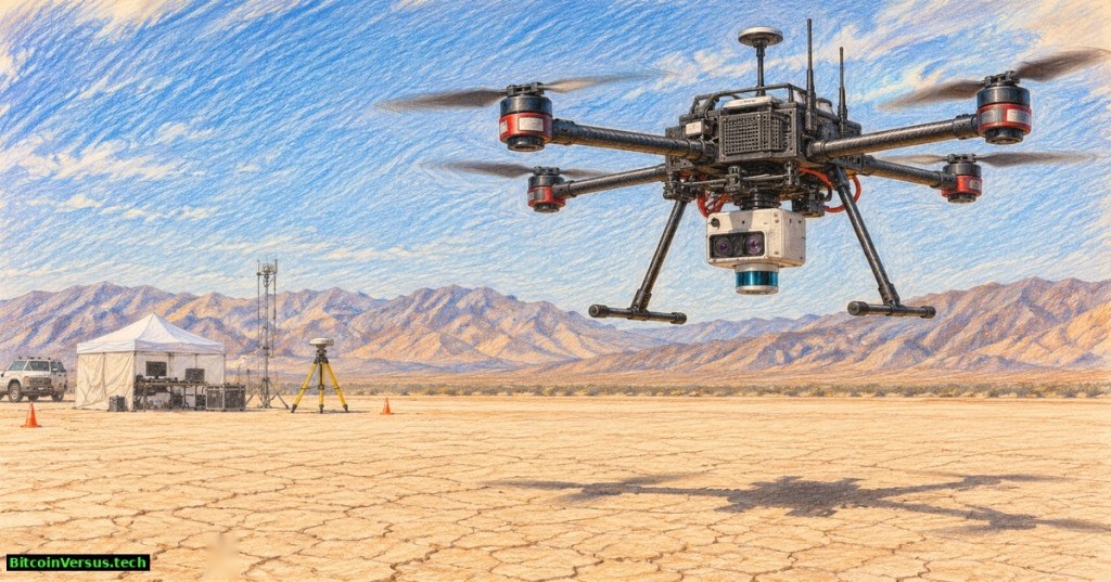
NASA has tested an autonomous landing guidance system aboard a drone, marking another step toward spacecraft that can identify dangerous terrain before touching down on the Moon. The Safe and Precise Landing, Integrated Capabilities Evolution project, or SPLICE, completed simulated lunar descent and landing maneuvers on August 27, 2026, at Rogers Dry Lake in California. NASA announced the results on November 4. The aircraft flew over Earth, not the lunar surface, and the agency has not claimed a complete Moon landing.
An Alta-X drone carried the test equipment near NASA’s Armstrong Flight Research Center. According to NASA’s flight-test report, the payload created detailed elevation maps, evaluated prospective touchdown zones and used guidance algorithms able to divert from an unsafe target toward a safer one. A remotely piloted aircraft served as the test platform while engineers evaluated the landing technology.
NASA Langley Research Center’s 2021 SPLICE explainer describes the sensors and mission concept. Archival background, not footage of the August 2026 flight.
How a spacecraft learns where to land
SPLICE combines several technologies that solve different navigation problems. A terrain-relative navigation camera compares live surface images with stored maps to estimate location. A navigation Doppler lidar measures speed and height using laser reflections. A hazard-detection lidar scans rocks, slopes and craters, producing a three-dimensional representation that software can evaluate.
A descent and landing computer coordinates the measurements and selects landing options. NASA also describes adaptive guidance software that can redirect a vehicle after a better site is identified. The distinction matters because a landing point that appears suitable in an orbital image can contain obstacles invisible until the spacecraft approaches. NASA’s SPLICE technical overview explains the integrated architecture and the history of earlier rocket, helicopter and ground tests.
In a representative lunar descent concept, the navigation Doppler lidar begins working around 10 kilometers above the surface, while the hazard-detection lidar can build a close-range terrain map around 500 meters altitude. Those figures describe the planned lunar landing architecture, not measured flight altitudes for the Alta-X drone. The recent demonstration instead tested guidance and terrain assessment in a controlled terrestrial environment.
Why the test matters
Autonomous hazard avoidance could let lunar missions approach scientifically valuable locations near craters, steep terrain and permanently shadowed regions with fewer demands on ground controllers. Our earlier explainer on how lunar landers survive touchdown describes the environmental and mechanical challenges that remain even after a safe target has been chosen.
NASA EDGE’s 2020 interview with SPLICE engineers explains the earlier program and sensor work. The video predates the August 2026 drone experiment.
The new experiment belongs to a broader movement toward spacecraft performing complex tasks without immediate human intervention. Caltech’s robotic orbital assembly experiment tested construction in space, while ESA’s Hera mission uses thermal sensing to examine an asteroid. Both illustrate how specialized sensors can expand autonomous operations, although neither validates SPLICE’s landing performance.
What still needs proving
The drone test did not reproduce lunar gravity, the vacuum environment, rocket-engine exhaust or all the dynamics of a descending lander. Integrating optical sensors, flight computers and trajectory control into an actual spacecraft requires additional qualification, fault tolerance and mission-specific tests. Dust, lighting and terrain features can also complicate sensor measurements.
NASA reported earlier communications and handling tests in June and July 2026 before the August maneuvers. The agency said flight experience had advanced the system’s technology readiness and described coordination with industry, but did not announce a named mission with a committed SPLICE installation date. Related aircraft testing, including the agency’s modular NASA flight research platform, provides another example of validating hardware and software before real-world deployment.
The important result is a successful step in the testing chain: NASA has shown landing guidance responding to sensed terrain on an aircraft, bringing the technology closer to operational use. A fully autonomous lunar touchdown using the integrated suite remains a separate future milestone.
Primary sources
- NASA Armstrong, November 4, 2026: flight-test report
- NASA SPLICE technical architecture and milestones
- NASA/Ryan Kline, August 27 flight-test photograph and September 24 image release
Editor’s Note: We volunteer daily to ensure the credibility of the information on our platform is Verifiably True. If you would like to support our work and the integrity of our research initiatives, scan the QR code below to donate 5,000 sats.

For mobile scanning, open the article on another display and scan the QR code with a Bitcoin wallet. Verify receiving address 3C9o19EH5HSiwEPyCTmEKzxhNCbo2X6TTb before sending.
Disclaimer: BitcoinVersus.Tech reports on engineering demonstrations and scientific research for informational purposes. Experimental results do not establish readiness for crewed flight or certify any spacecraft for mission use.


Leave a Reply